LAKEL GROUP
BITUMEN

BITUMEN BLOCK IN OKITIPUPA-ONDO STATE
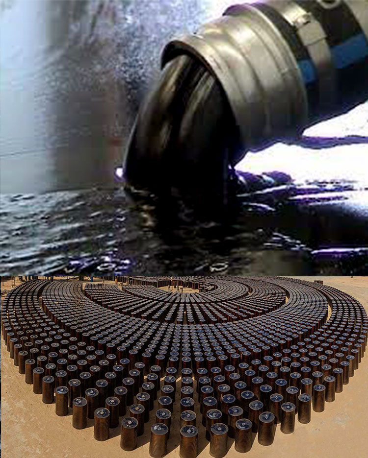
Ondo state Bitumen has chemical composition, consisting mainly of hydrocarbons, with a high carbon content of between 80% and 90%. At normal ambient temperatures it is solid to semi-solid but becomes progressively more liquid at high temperatures.
▪ Bitumen can be modified or given specific qualities by further processes. These include blowing air through the bitumen mix to give it higher viscosity and greater resistance to softening (particularly for road applications), and secondary processes involving additives or emulsifying with water.
▪ The many uses for bitumen include road surfaces, pavements, roofing and roofing fel
Summary on exploration license:
▪ Exploration license bitumen block covers an area of 59.2 km2 location: onshore, okiti-pupa, ondo, Nigeria prospective resources: billions of barrels of bitumen at development stage
▪ Lakel Afrik Petroleum is the license holder: The license was granted to Lakel on the 12th of October 2018 and ML to start mining 2020 and to develop the area into a bitumen production for local consumption and to be exported to the End Users World-wide.

In any development of a resource to be mined there are six key stages
PROPERTIES
Stage 1 - Prospecting/Surveying
The first stage in the mining process is to identify areas where a particular ore is likely to be found. There are two methods that can employed during this stage: Visual examination of deposits found on or near the surface or Scientific investigation of deposits found deeper in the land using methods such as gravimetric, magnetic, radiometric or seismic data acquisition.
Stage 2 - Exploration
In this stage there is a physical interaction with the deposit, normally through the process of drilling and coring to extract physical samples. These core samples are collected for the purpose of evaluating the grade, weight and consistency of deposits. Once the resource estimation — meaning, the value of the deposit—is determined, a feasibility study must then be conducted to help determine whether to abandon or develop the deposit.
Stage 3 - Mine design/planning
Once it is decided to work on the site, the designing and planning stage begins. This entails the commissioning of studies that help determine whether the project is Safe, Socially responsible, Environmentally sound and Economically viable
Stage 4 - Development
This stage of the mining process requires establishing a path to the mineral deposit. It is this stage which involves significant capital expenditure before any revenue can be anticipated and can be a lengthy process.
Stage 5 - Production
The excavation and stripping of the ore, and either transporting the ore to a processing facility, or processing on site and shipping of the final product.
Stage 6 - Closure/Reclamation
Once the ore has been processed and/or shipped away for sale, the final step of the mining process begins. The land which was used to obtain these resources must be rehabilitated as much as possible.
The objectives of this process include:
• minimizing environmental effects
• ensuring public health and safety
• preserving water quality
• establishing new landforms and vegetation
• removing waste and hazardous material
• stabilizing land to protect against erosion
SEISMIC SURVEYS
Land seismic surveying applies the science of sound energy and seismology to map geological structures beneath the earth surface. A seismic survey is conducted by creating a shock wave – a seismic wave – on the surface of the ground along a predetermined line,using an energy source. The seismic wave travels into the earth, is reflected by subsurfaceformations, and returns to the surface where it is recorded by receivers called geophones -similar to microphones. The geophones are mounted on cables known as streamers.
The seismic waves are created either by small explosive charges set off in shallow holes (“shot holes”) or by large vehicles equipped with heave plates (“Veibroseis” trucks) that vibrate on the ground. By analysing the time, it takes for the seismic waves to reflect off ofsubsurface formations and return to the surface, a geophysicist can map subsurface formations and anomalies and predict where oil or gas may be trapped in sufficient quantities for exploration activities.
Various seismic surveys conducted on the block include the following:
- 2-D & 3-D Survey:
Two dimensional (2-D) surveys use one sound source and one streamer while Three- dimensional (3-D) surveys use two sound sources and multiple sets of streamers.
- 4DS 4-D Survey:
4D surveys are 3D seismic surveys repeated over a period of time in order to observe reservoir depletion during production and identify areas where there are barriers to flow that may not be easily detectable in conventional seismic.
Interpretation of Seismic Data
The collected data went through several processing steps to improve the quality of the signals and filter out background “noise.” Geophysicists then interpret the information to develop a detailed picture of the structures and rock formations in the survey area. The results of the survey are interpreted lines and maps showing geological features. Specific features that indicate whether oil or gas might be present were observed, analysed and recorded. These include former sedimentary basins, buried former beaches, faults and ancient reefs that can act as underground traps for crude oil and natural gas.


Seismic information helped the company decide whether:
- The available information is sufficient to justify drilling an exploratory well
- Additional surveys are needed to better define the structures before drilling
- The features present are not attractive enough to warrant further interest
EXPLORATORY DRILLING PROCESS
The data collected from the geologic and geophysical surveys are used to formulate probable definitions andrealizations of the geologic structure that may contain heavy oil / bitumen. However, we still have to determine whetherheavy oil/bitumen exists in these geologic traps, and if it does exist, would it be available in such a quantity that makes the development of the bitumen field economical?


50 exploratory wells were drilled in locations determined by the geologists and geophysicists. The wells were drilled with insufficient data available about the nature of the various rock layers that will be drilled or the fluids and pressures that may exist in the various formations.
As these exploratory wells are drilled, samples of the rock cuttings are collected and examined for their composition and fluid content. The data are used to identify the type of formation versus depth and to check on the presence of hydrocarbon materials within the rock. Cores of the formations are also obtained, preserved, and sent to specialized laboratories for analysis.
